
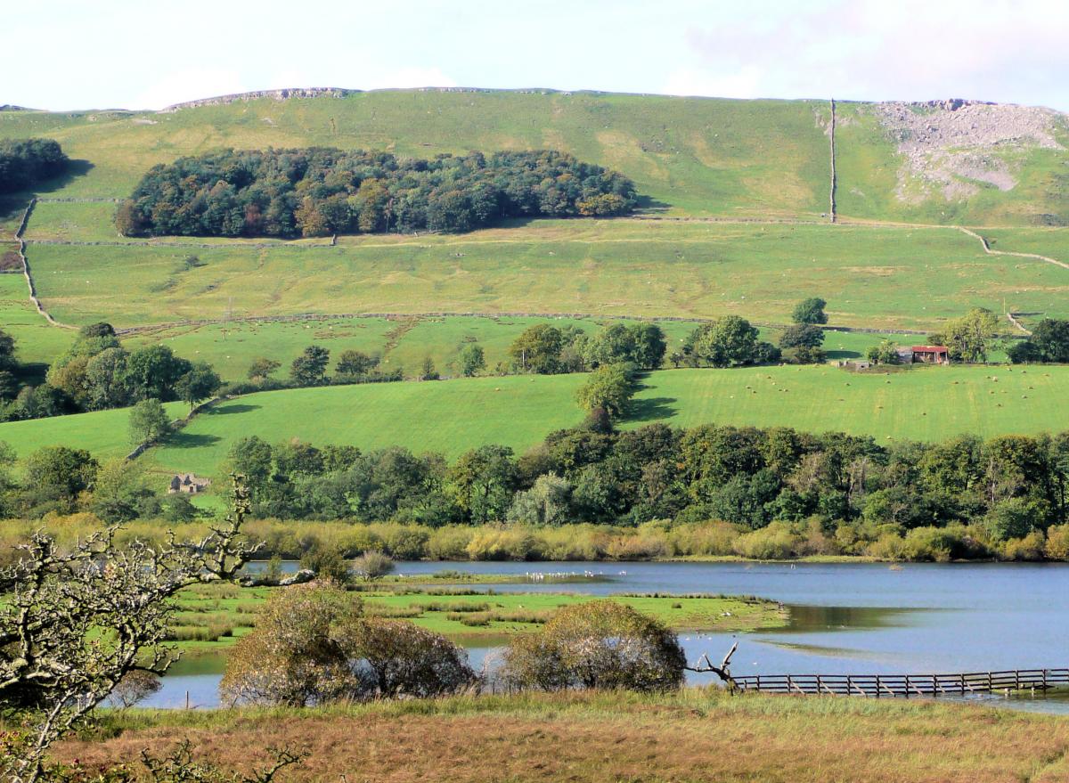
Semer Water is one of only two natural lakes in the Yorkshire Dales. It is less well known than the other, Malham Tarn, and is tucked away on a side dale to the south of Bainbridge in Wensleydale. It is managed by the Yorkshire Wildlife Trust.
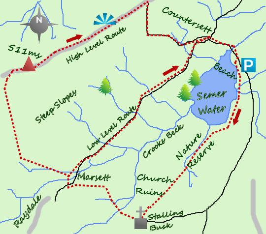
Semer Water is little over a mile from the pretty village of Bainbridge. There is limited parking down the steep hill from Countersett, which makes a good place to start the walk. The parking is next to a small beach, a lovely spot sometimes used as a launching pad for some organised children's activities.
The walk heads along the road to Low Blean Farm and the path that heads due south from here towards Stalling Busk. The path winds its way through Semer Water Nature Reserve. Oyster catchers, snipe and curlew are just some of the birds that you may see, whilst the open water supports the unusual yellow water lily.

The only other natural lake in the Yorkshire Dales is Malham Tarn (similar sized) and that has been artificially raised, whilst Semer Water was formed naturally at the end of the last ice age when fluvial deposits filled the outflow creating the lake.
Be aware though, after heavy rains this section of the walk can become very wet and the lake rises surprisingly quickly.
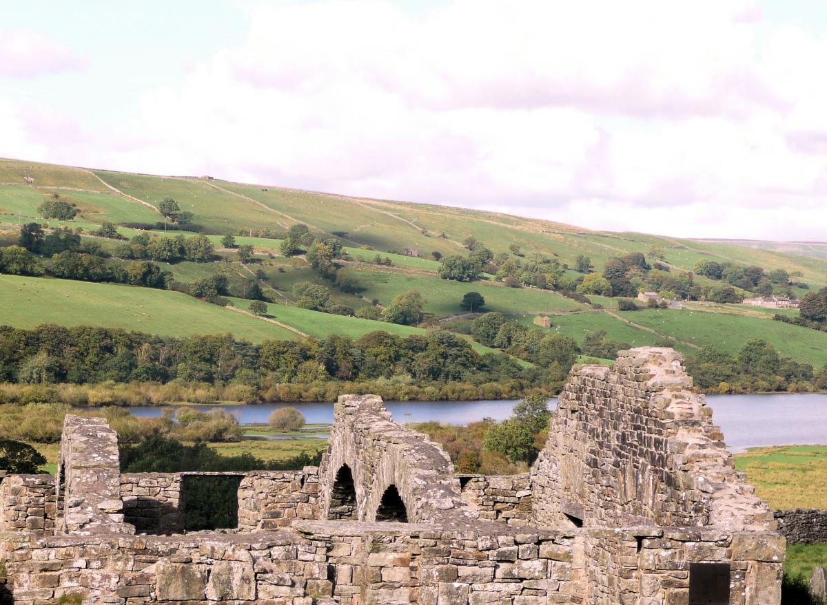
The path continues beyond the southern end of Semer Water until it reaches an old ruined chapel and graveyard, the chapel built in 1772. Take the left hand path here which climbs in to the little hamlet of Stalling Busk. A pretty church, St Matthew's, lies in its centre, this one in much better condition. Stalling Busk marks the end of the road in the valley (which has run along 100 metres above the path).

From the church, head west down a steep track towards Crooks Beck (one of the two rivers which feed Semer Water). Two footbridges lead towards the hamlet of Marsett.
Marsett is a collection of holiday cottages and two farms. It is in Marsett that there is a choice of route back to the start. The best route in bad weather is via the road which follows the north west shores of Semer Water.
In good weather take the steep climb up the hillside to the shoulder of Wether Hill. To find the path, cross the bridge in Marsett and then take the farm track west, but after 200 metres and before it becomes steep, take the footpath to your right for a short sharp climb.

The reward for the steep climb is wonderful views across Raydale towards the distinctive, flat topped peak of Addleborough. Semer Water is revealed in all its glory, nestling, tear dropped shaped, in the valley bottom. The path reaches a bridleway on the broad moorland ridge, turn right and follow this for one mile to the quiet road above Countersett. From Countersett drop down the road to your car.
Like the look of this walk? Check out some of Jonathan's previous suggestions here:
- An easy walk on the banks of a North Yorkshire river overlooking beautiful villages
- Dam workings and a drowned village on this reservoir walk
- See a castle, a ruined abbey and wonderful riverside paths on this one-way walk
Get more from The Northern Echo with a Premium Plus digital subscription from as little as only £1.50 a week. Click here for details.

WALK FACTS:
Distance: Low level, four miles. High level, five and half miles.
Height to climb: 350m (1,150 feet) on the high route. 100m (330 feet) on the low level route.
Start: SE 922875. There is a small car park near the beach.
Difficulty: Easy to moderate.
Refreshments: There is a café and pub in Bainbridge, one and a half miles away.
Be prepared: The route description and sketch map only provide a guide to the walk. You must take out and be able to read a map (O/S Explorer OL30) and in cloudy/misty conditions a compass. You must also wear the correct clothing and footwear for the outdoors. Whilst every effort is made to provide accurate information, walkers head out at their own risk.
Please observe the Countryside Code and park sensibly.
Jonathan Smith runs Where2walk, a walking company based in the Yorkshire Dales. He has published three books on walking in the Dales, The Yorkshire 3 Peaks, The Dales 30 mountains and Walks without Stiles. All these books (and more) are available direct from the Where2walk website.
Book a navigation (map and compass skills) training day near Settle or a bespoke day for a private group. The first available day is March 23. Join our “Dales 30 Weekenders” in Hawes and Sedbergh.
Where2walk.co.uk also features hundreds of walks across Yorkshire and beyond, from easy strolls to harder climbs.


Comments: Our rules
We want our comments to be a lively and valuable part of our community - a place where readers can debate and engage with the most important local issues. The ability to comment on our stories is a privilege, not a right, however, and that privilege may be withdrawn if it is abused or misused.
Please report any comments that break our rules.
Read the rules here