
BELMONT, Carrville and Broomside all lie east of Durham City and their history is closely linked to that of Gilesgate Moor.
Since the 1850s, all four areas have formed the parish of Belmont, that was annexed from the earlier medieval parish of St Giles in Gilesgate.
Today, the A1(M) motorway separates Belmont from Gilesgate Moor, creating two separate suburbs, but Carrville High Street and Broomside Lane, in Broomside, were formerly extensions of Gilesgate Moor's Sunderland Road.
Carrville and Broomside began as independent communities, but collieries and, later, an ironworks developed here. These industries also stimulated population growth in neighbouring Gilesgate Moor.
As mining settlements grew, pubs, schools and chapels sprang up in these areas to serve the communities, and their histories are inextricably linked.
Carrville High Street and Broomside Lane are the main thoroughfares of the area and the two streets merge at Moor End, where they continued into Durham as the Sunderland Road.
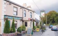
Moor End, though easily missed by passers-by, has a village-like appearance and is best known as the home of a pub called the Sportsman's Arms.
It was still isolated by fields from the rest of Carrville High Street as late as the 1950s.
Moor End, though technically the eastern terminus of Gilesgate Moor, became separated from Gilesgate Moor with the construction of the motorway and is now more closely associated with Carrville and Belmont, though a road still links it to Gilesgate Moor by bridge.
Moor End is at the heart of the parish, as here we find the parish church of St Mary Magdalene hidden amongst the trees in a triangle of land between the two roads.
A well-known Victorian architect called Butterfield constructed the church in 1856 and it still serves communities on both sides of the motorway.
The church was built on land belonging to the Pemberton family, who owned the land between the two streets.
Even when we head east, where Broomside Lane becomes Pittington Lane and Carrville High Street becomes the A690, the land between the two roads belonged to the Pembertons.
At the heart of the Pemberton estate was Belmont Hall, built and named by Thomas Pemberton in 1820. He probably chose this fancy name to suggest a place of beauty.
His hall was built on the site of a farm called Ramside Grange, which in medieval times belonged to the religious establishment of Kepier Hospital.
Pemberton's hall incorporated parts of the earlier grange.
In the 1500s, Ramside Grange became the property of John Heath, who granted the Ramside portion of his estate to one of his younger sons, called Edward Heath.
Ramside passed in the later 1600s to the Smith and Martin families before it was bought, in 1737, by the Huttons of Marske.
In 1749, Ralph Gowland purchased Ramside, but sold the property 20 years later to John Pemberton, of Bainbridge Holme Hall, in Sunderland.
Pemberton's son, Stephen, subsequently sold Ramside to the Hopper family, but the Pembertons acquired the property again in 1820.
The Pembertons also owned Hawthorn Tower, near Easington, and are principally famed for opening Sunderland's Monkwearmouth Colliery in the 1830s.
Also called Pemberton Main colliery, this was, for a time, the deepest colliery in the world. It was the last colliery in the Durham coalfield to close, in 1994, and is now the site of Sunderland AFC's Stadium of Light.
The Pemberton family, who were later called Stapylton Grey Pemberton, left Belmont Hall in 1947 and in 1963, the hall became a hotel, reverting to its original name of Ramside.
Carrville developed as a long terrace of miners' houses along the northern edge of its High Street. The land belonged to the Carr family (also called Standish-Standish), while Broomside village developed on Pemberton land on the north side of Broomside Lane.
Linking the two streets at their eastern end was Bainbridge Street, which still exists today. Named after Pemberton's property in Sunderland, the terraced houses in this street were associated with Broomside rather than Carrville.
Carrville's nearest colliery was Kepier Grange Colliery.
Not to be confused with Kepier Colliery in Gilesgate Moor, it opened about 1844 and was connected by a wagonway to the Durham branch of the North-Eastern Railway's Leamside line. The Leamside line still exists east of Belmont, but its branch line along the course of the present A690 into Durham has gone.
Kepier Grange Colliery was located on Standish-Standish land in what is now Belmont Industrial Estate. Its colliery wagonway terminated near Kepier Grange Inn in Carrville High Street and presumably supplied coal to the village and pub.
Just north of Kepier Grange Colliery, but on the same branch line, was Grange Colliery, that opened at about the same time. It stood on the Marquis of Londonderry's Grange or Low Grange Estate and this colliery site is located next to the A690/A1(M) motorway intersection, where a caravan site is now located.
The colliery had closed by 1867, when the site became an ironworks. A terrace called Wood Row was built nearby to serve the colliery, followed by the adjoining Grange Row and Vane Terrace, which served the ironworks. Vane was of course the Marquis of Londonderry's family name.
These three streets were demolished in the late 1960s to make way for the motorway intersection that stands on the site.
North of Belmont Hall was yet another colliery. Called Belmont Colliery or Furnace Pit, it dated from the 1830s and is now marked by a site called the Rift. Linked to a network of wagonways serving collieries at Pittington, it was owned by the Bell family and appears to have closed in the 1870s.
East of the Leamside line near Broomside is Hill Top Farm, on the site of the original settlement called Broomside.
First mentioned in the 1400s, it changed its name to Hill Top in the 19th century.
In 1829, Broomside Colliery, or the Lady Adelaide Pit, was established just east of here.
Initially belonging to the Marquis of Londonderry's family, it came into the ownership of the Bells, but closed by the 1890s. It seems that Belmont and Gilesgate Moor were once very busy colliery districts.


Comments: Our rules
We want our comments to be a lively and valuable part of our community - a place where readers can debate and engage with the most important local issues. The ability to comment on our stories is a privilege, not a right, however, and that privilege may be withdrawn if it is abused or misused.
Please report any comments that break our rules.
Read the rules hereComments are closed on this article