

HUGE swathes of Teesside are at risk of being flooded every year in the next decade, a study has discovered.
Independent organisation Climate Central has mapped the places around the world that could be affected by flooding through combinations of sea-level rise, tides and storm surges.
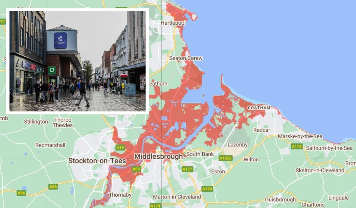
One map has identified places that will be below the annual flood level by 2030, meaning they are at risk from coastal floods on average once per year.
However, in some years there could be more than two incidents and in other years there may be none.
Read more: Teesside Airshow announces even MORE exciting displays after five year break
In Teesside, the areas that might be affected include parts of Redcar and Hartlepool and areas in Middlesbrough and Stockton that are next to the River Tees.
The interactive map shows that all of Teesside Park, the Riverside Stadium, and Middlesbrough College could be at risk of yearly flooding by 2030, which could even reach as far inland as Yarm.

Major roads, including the A19 and A66 have the potential to be affected, which could cause chaos for motorists.
However, the data is not 100% reliable as the maps are created by using huge datasets, which Climate Central says “always include some error”.
Read more: 'Broke the laws he put in place': North East Labour MPs on why Boris Johnson should resign
Therefore, the maps should be used to identify places that could require “further investigation” of risk.
The interactive tool does not provide current data, as it is based on projections, so it is not clear how much worse it will be than the present situation.
Also, the map is not as accurate when considering risks from extreme weather. Climate Central states: “Our approach makes it easy to map any scenario quickly and reflects threats from permanent future sea-level rise well.
“However, the accuracy of these maps drops when assessing risks from extreme flood events. Our maps are not based on physical storm and flood simulations and do not take into account factors such as erosion, future changes in the frequency or intensity of storms, inland flooding, or contributions from rainfall or rivers.”
Read more: 'Broke the laws he put in place': North East Labour MPs on why Boris Johnson should resign
There is a long history of flooding in the Tees catchment area, with records showing Croft, Neasham, and Yarm being affected since 1684. Reasons for flooding in the region differ dependent on location and could be due to heavy rainfall, melting snow, or high tides.
There are schemes in place across Teesside to lessen the impact of flooding on the area. The Port Clarence and Greatham South project has increased flood protection for residents in the area from the River Tees and Greatham Creek.
There has been a new habitat created at the site for local wildlife, which is equivalent to the size of 90 football pitches.
Read more: Drivers could strike affecting Darlington Greggs and McDonald's over £1.10 pay cut
The Marton West Beck flood scheme has improved protection for around 500 homes and businesses while reducing the risk of flooding from the beck, sea, and surface water in central Middlesbrough.
The government has committed £5.2bn to create 2,000 new flood and coastal defences between 2021 and 2027. As part of this, every area of England will have a strategic plan to deal with flooding and coastal erosion “from source to sea”.
--
Keep up to date with all the latest news on our website, or follow us on Facebook, Twitter and Instagram.
You can also follow our dedicated Teesside Facebook page for all the latest in the area by clicking here.
For all the top news updates from right across the region straight to your inbox, sign up to our newsletter here.
Have you got a story for us? Contact our newsdesk on newsdesk@nne.co.uk or contact 01325 505054


Comments: Our rules
We want our comments to be a lively and valuable part of our community - a place where readers can debate and engage with the most important local issues. The ability to comment on our stories is a privilege, not a right, however, and that privilege may be withdrawn if it is abused or misused.
Please report any comments that break our rules.
Read the rules here