
Richmond was once a rotten 'pocket' borough, but it is an area richly steeped in history and mystery, and washed up old ironworks.
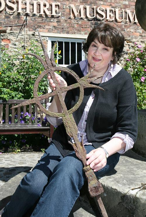
Hand-forged by a blacksmith, a curiously fine piece of ironwork has emerged from the stony bed of the Swale after perhaps lying lost for a century or more. But what is it? It could, of course, just be some strange agricultural implement that has been washed down from the upper dale, but it was found near the site of one of Richmond’s greatest lost mansions, so could it possibly once have decorated its grand Georgian gardens?
RICHMOND now boasts that it has the Foreign Secretary as its MP, whom it democratically elected with a majority of more than 23,000 – one of the largest in the country.
But once Richmond was a rotten “pocket” borough.
In the 16th Century, Queen Elizabeth decreed that only the people who owned the 273 houses in the town could vote.
This meant that if a single person was wealthy enough to buy up 137 houses – half the votes – they could return anyone they liked to the House of Commons. Even themselves – the seat was in their pocket.
And so it was in 1651 when John Yorke took the hand, and property, of Mary Norton in marriage. John came from Goulthwaite Hall, Nidderdale; Mary’s family lived at St Nicholas, Richmond – near Easby Abbey. Her dowry included 40 acres of land on Richmond Green and “the decayed castelet called Hudswell pele and other premises”.
Peel towers are most commonly found along the Scottish border. They are small fortifications which, by law, had to have an iron basket at the top in which a beacon could be lit in the event of a Scottish rampage.
Near the tower, in 1659, John began to build himself a mansion.
He also began buying up more property. In 1660, the newly-restored King Charles II knighted him, and in 1661 he had enough property to ensure he had pocketed enough votes to elect himself as one of the town’s two MPs.
It didn’t do him much good, because he died after only two years in the Commons, but he was the first of four Yorkes to represent the town for a total of 65 years.
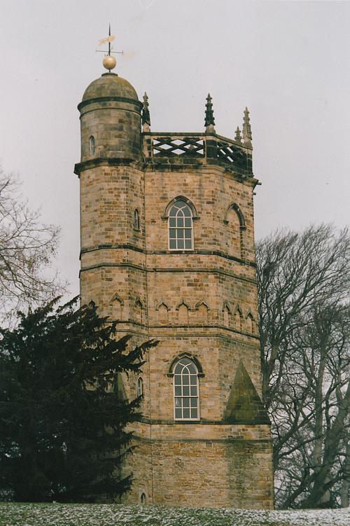
One of them, John, his grandson, was so delighted when the Scots were finally vanquished at the 1746 Battle of Culloden that he replaced “the decayed castelet” with a folly in the shape of a tower.
It was designed by Daniel Garrett – one of the principal architects in the North-East who worked at Raby Castle and Stanwick Park, near Darlington, and is best remembered for the Banqueting House, at Gibside.
Garrett’s architecture celebrated the Scots’ defeat: the ground floor is in the old Gothic style in which the Catholics traditionally built their churches, and the dominant upper floor, crushing down on the Scots’ religion, is in the Classical style of the Protestants.
As the 18th Century wore on, the Yorkes’ star began to wane and financial difficulties forced them to sell their mansion at the start of the 19th Century.
It was demolished in 1823.
By then, Richmond Green probably wasn’t as desireable as it had been in Sir John’s day.
Weavers had moved into the cottages, so they could use the Swale’s water, and other, foulsmelling industries had come in with them. There was a tannery, which used stale urine to create leather, and a fishsmoking warehouse.
Today, the Green is far more attractive, but still a couple of bed and breakfasts hark back to the industrial past. One is called The Old Brewery and another, in an old farm byre, is called the Old Cello Workshop because stringed instruments were once made there.
Perhaps the most striking of all the tourist accommodation in the district is the Yorkes’ Culloden Tower, which has recently been restored by the Landmark Trust.
It is the last remaining trace of the Yorkes’ mansion – unless the recently-discovered ironwork is a piece of tracery that once adorned the garden.
MARY Norton’s father was called Maulger Norton. What a fine name!
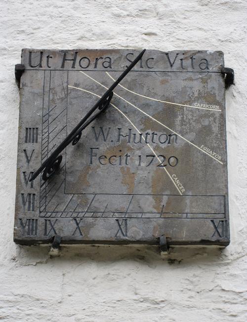
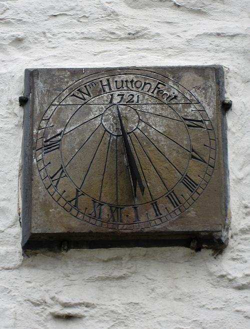
BEFORE we leave Richmond Green, we must stare at one of Echo Memories’ great fascinations: sundials. A house has two sundials: one facing south, the other facing east – the only known double dial in the North-East.
The east dial is dated 1720 and tells the time to noon. It also bears the legend “Ut hora sic vita” – “Life is as an hour”.
This is probably the most common sundial motto in the land, appearing on dials from Devon to Northumberland, including Stanhope church, in Weardale.
The south, more conventional, dial is dated 1721 and bears the name of the man, William Hutton, who made, or “fecit”, both dials. He lived in the corner house and must have had too much time on his hands.
THE three-arch Green Bridge spans the Swale at the end of Richmond Green. It was rebuilt in 1788-89, replacing a four-arch bridge which was swept away in the Great Flood of 1771 – a terrible inundation which overwhelmed all North-East riverside communities.
The centre of the bridge marks the boundary between the borough of Richmond and the North Riding of Yorkshire.
It is said that the two authorities could not agree who should build the replacement bridge, and so a Richmond builder started work on the northern side and an Askrigg builder on the southern side.
Fortunately, they met in the middle.
However, it is also said that the Green Bridge was designed by John Carr (1723- 1807) who, as regular Memories readers will know, was the greatest bridge-builder of his day (Greta, Asygarth, Croft and Yarm to name but four others of his).
It certainly looks like a Carr – solid and powerful, a perfect foil for the solid and powerful castle behind it.
Carr was an amazingly methodical man. As he was away from his York home bridgebuilding all the working week, he took a large pork pie which, using his compasses, he divided into six equal portions – one for each evening he was away.
Such a man would surely not have tolerated bickering local authorities – but you can still see that the Askrigg builder used two courses of stone blocks to build the parapet on his southern side, whereas the Richmond man used three.
Two inscribed stones separate the two men’s work.
Carved into the west parapet are the names of the Richmond mayors in 1788-89: H Blegborough and T Hogg.
Carved into the south side is a milestone: Askrigg 18 and Lancaster 56. This marked the start of the Richmond to Lancaster turnpike toll road.
One has always wondered why Askrigg, of all the villages en route, was singled out by the stonemason – perhaps it was because it was his home village.
THE Green Bridge leads over the Swale to the hamlet of Sleegill. Until 1913, the first building in Sleegill was a pub called The Good Intent. Beside it is a riverside path which, if you choose the steep upward slope, quickly leaves you breathlessly looking over breath-taking views of Culloden Tower and The Green.
The path leads through Billy Bank Wood, where copper miners toiled, and then reaches Round Howe.
Our ancestors must have thought this curious domed hill was once a burial place and so they called it a “howe”. However, it is apparently a glacial formation: as the glacier swept down Swaledale it met a lump of uncommonly hard rock. As it couldn’t gouge the rock out of its way, it split in two and slid by it, smoothing its sides.
It was from this direction that artist JMW Turner first approached Richmond. In 1799, he sat by the river and painted Green Bridge and the roofline of Yorkes’ mansion, and in 1816, he sat on Round Howe and painted the outline of Richmond Castle through summer’s golden haze.


Comments: Our rules
We want our comments to be a lively and valuable part of our community - a place where readers can debate and engage with the most important local issues. The ability to comment on our stories is a privilege, not a right, however, and that privilege may be withdrawn if it is abused or misused.
Please report any comments that break our rules.
Read the rules here