

Starting and finishing at the pretty village of Clapham offers my favourite route up Ingleborough.
On the climb there is woodland, caves (including Gaping Gill), a deep gorge and an airy pull. On the descent is possibly a path through the finest area of limestone in England.
From the National Park car park turn right, head up past the playground, cross the bridge over the river and continue up to the entrance of the Clapham estate. There is an entrance fee to walk besides the lake and through the delightful woodland. The walk through the exotic woodland has a story to tell with much of the trees and plants originating in the far east.
On emerging from the woods a short walk approaches Ingleborough Cave. If you have qualms in paying for the walk, a right of way climbs to the north of the woods (starting a few metres further on than the estate) and drops back down to the track at Ingleborough Cave.
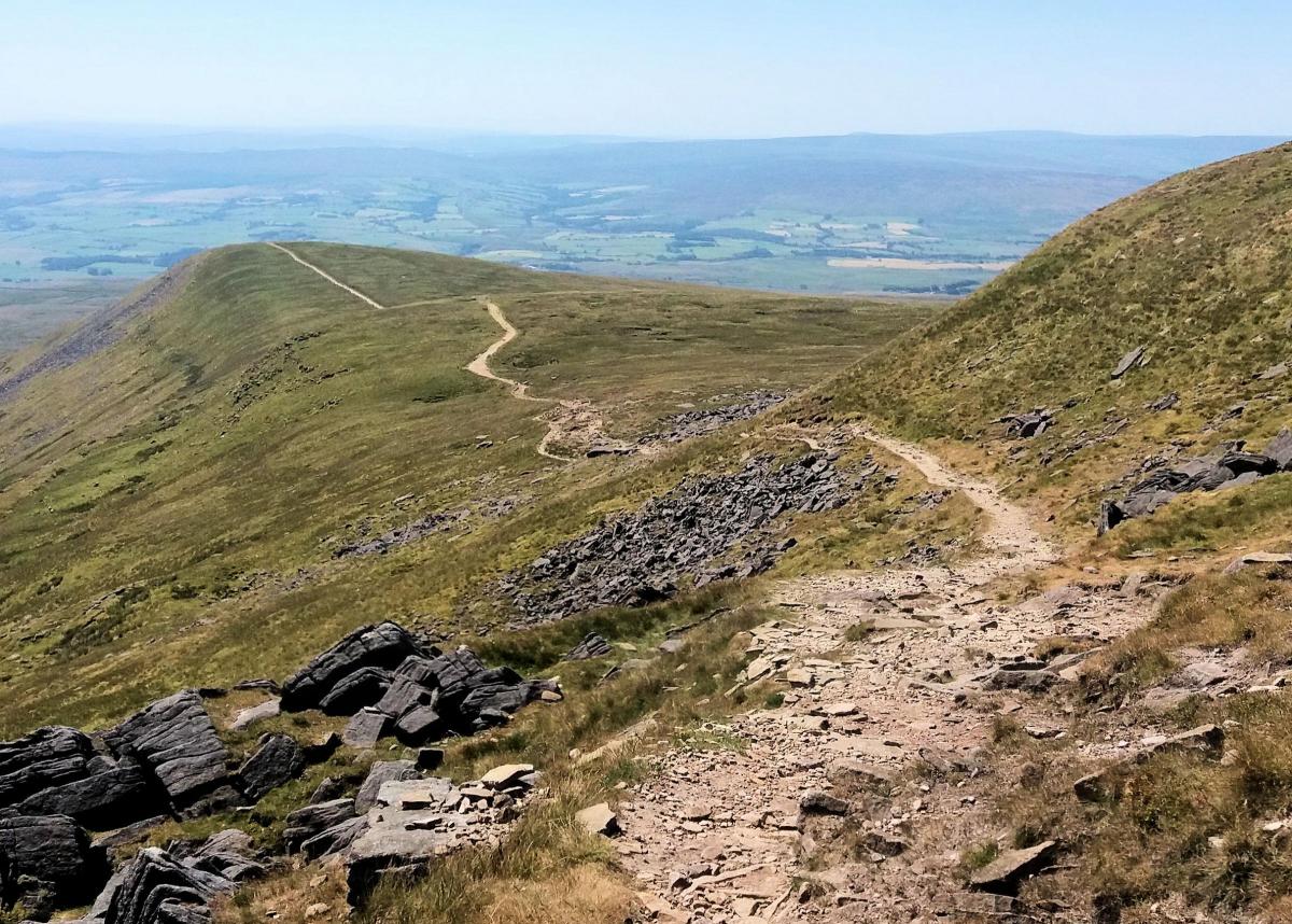
Two hundred metres beyond the cave the track turns sharply left and heads North West through Trow Gill. Possibly formed by a collapsed cavern and the source of the original river from the upper slopes of Ingleborough, Trow Gill is now dry with precipitous rocky sides. Clamber over the rock and after a further 200 metres pass through a stile and on to the open slopes of Ingleborough. An excellent example of a limestone pavement is on the left.

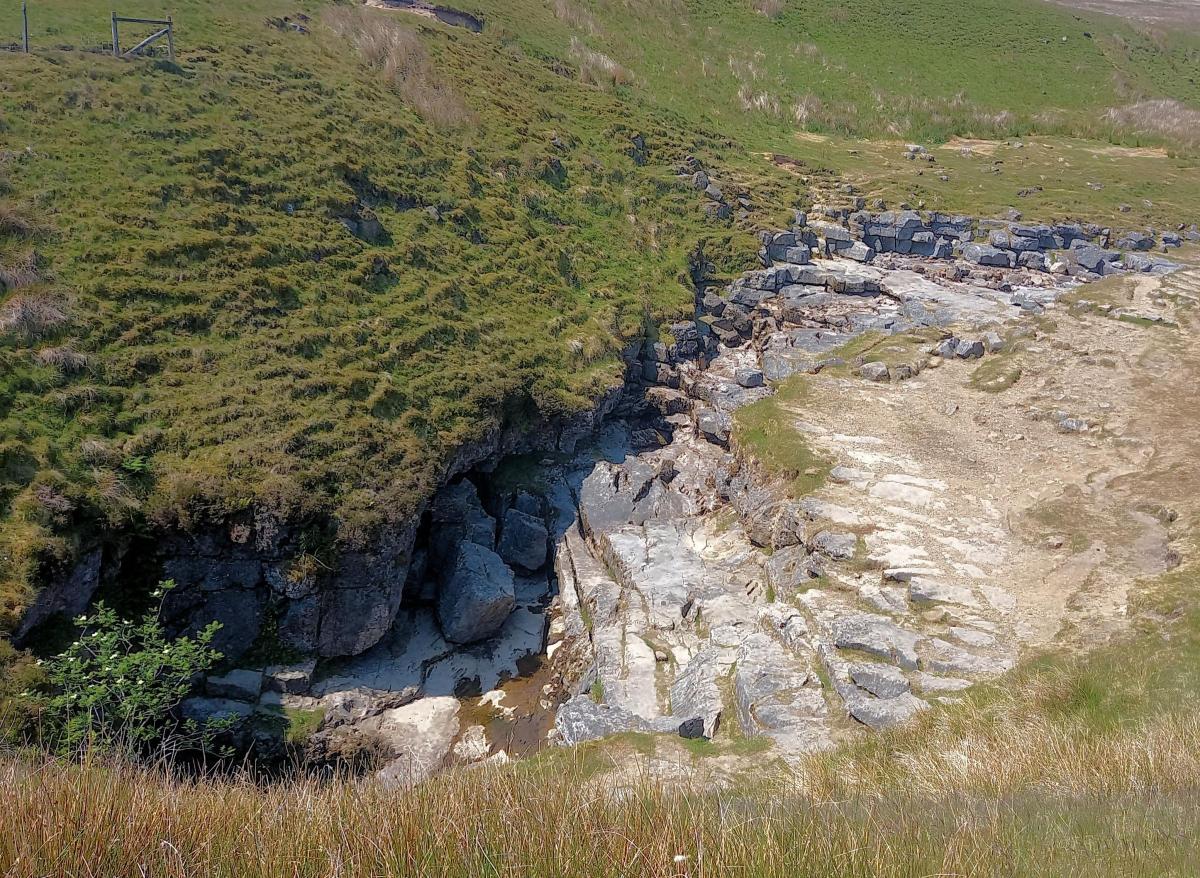
The path can be seen climbing steeply, just west of north. However, before the climb a path heads off to the right leading to Gaping Gill, a 100 metre pothole and one of the most famous landmarks in the Yorkshire Dales. Apparently York Minster could fit inside the cave. The stream which falls into the cave appears a mile downhill at Ingleborough Cave, a remarkable but typical feature of the limestone rock of the area.

Return to the main path and climb steeply to the cairn that marks Little Ingleborough. A lovely path then heads due north along a ridge for 300 metres before skirting to the right and climbing on to the vast summit plateau of Ingleborough at another prominent cairn. The rocky summit plateau of Ingleborough is featureless and in mist can be confusing. Head due west from the cairn for 220 metres to the large cairn, trig point and shelter of Ingleborough, the views are fantastic, particular to the north and west where the Lake District and Morecambe Bay can be seen on a good day.
Keep to the northern rim of the summit plateau heading west to a rocky path next to a prominent boulder. After 50 metres the track divides. Take the right hand fork and join the main path to Horton. Follow this for two miles. Soon after passing a collapsed sheepfold and after a small river the path divides at a wall. Take the right hand fork (much fainter track) initially alongside the wall and soon enter a quite superb area of limestone pavements. I do not believe there is better in the country.

After three quarters of a mile at a meeting of paths turn right on a grassy wide path. The path heads just south of west and drops slowly to a gate above Trow Gill. Here the path becomes a walled lane, follow it for the final one and a half miles to Clapham.
WALK FACTS:
Distance: Roughly ten miles.
Height to climb: 630m (2,345 feet).
Start: SD 745692. A large National Park car park 50 metres past the New Inn hotel.
Difficulty: Hard. A long day (take time to explore) with mixed terrain, particularly rough on the summit and through Trow Gill.
Refreshments: There is hotel, the New Inn, a fine bar/café at the car park and a further café at the entrance to the Clapham estate.
Be prepared: The route description and sketch map only provide a guide to the walk. You must take out and be able to read a map (O/S Explorer OL2) and in cloudy/misty conditions a compass. You must also wear the correct clothing and footwear for the outdoors. Whilst every effort is made to provide accurate information, walkers head out at their own risk.
Please observe the Countryside Code and park sensibly.
Read some of Jonathan's previous walks:
- See these two standout monuments on a seven-mile walk in the Yorkshire Dales
- See this unique barren moonscape on a six-mile walk high in Yorkshire
- Experience remarkable oaks on a scenic riverside walk to a ruined abbey

Jonathan Smith is the owner of Where2walk, a walking company based in the Yorkshire Dales. He has written three books on walking in the Dales, The Yorkshire 3 Peaks, The Dales 30 mountains and Walks without Stiles. All these books (and more) are available direct from the Where2walk website.
Book a navigation (map and compass skills) training day near Settle or a bespoke day for a private group. The first available day is March 23. Join our “Dales 30 Weekenders” in Hawes and Sedbergh.
Where2walk.co.uk also features hundreds of walks across Yorkshire and beyond, from easy strolls to harder climbs.


Comments: Our rules
We want our comments to be a lively and valuable part of our community - a place where readers can debate and engage with the most important local issues. The ability to comment on our stories is a privilege, not a right, however, and that privilege may be withdrawn if it is abused or misused.
Please report any comments that break our rules.
Read the rules here