
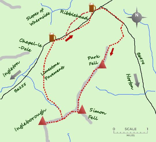


THIS week we are tackling an alternative climb of Ingleborough taking in Simon Fell and continual dramatic views across the Ribblehead viaduct to Whernside.
It explores the least visited side of this impressive mountain and this does make the paths themselves more pleasant to walk on.
Park at the T junction at Ribblehead where there is now plenty of parking (if you are lucky there may even be a butty van to delay your start!)
Head south east along the B6479 for little more than half a mile to a farm track near the railway cottages. Turn right at a signpost for Sleights and follow the lane round to Colt Park, a farm.
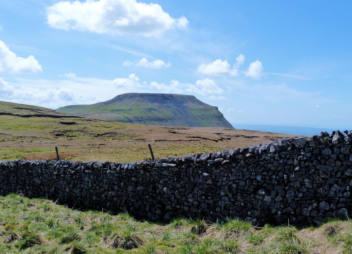
Cross through the gate and on to the slopes of Park Fell, a daunting site. Keep to the wall and head up the steep slopes, however make full use of the excuse to stop and admire the view behind you. The views of Pen y Ghent are particularly impressive.
The Trig point at Park Fell is eventually reached, drop down to the wall and carry on south west to the next slope. Ignore the obvious path to your right and carry alongside the wall till it arrives at the cairn marking the summit of Simon Fell at 650m. Simon Fell is one of the least visited Dales 30 mountains - those over 2,000 feet high.
It is one of the many reasons why the Dales 30 are such a good challenge, they take you to places you would not normally visit! From the cairn follow the wall south west and slightly downhill till you meet a stile and an obvious path that leads up to the summit plateau of Ingleborough.
This last, recently repaired section of path is known as the Swine Tail and has caused much grief to many trying to complete the 3 Peaks challenge.
The summit of Ingleborough is at the far end of this large rocky plateau complete with Trig point, large cairn and shelter (I still say standing on the shelter is the highest point). Return down the rocky path to the stile and turn left (north) down a steep path.
After 150 feet the path flattens and heads towards the bulk of Whernside. The route down passes some lovely limestone pavements in its lower half and as a descent is really very pleasant, the duck boards avoiding the worst excesses of the previously eroded path. From the foot of the steep slope it is nearly 2 miles to the road (B6255).
At the road there is a choice. The quickest route back is to turn right and follow the road the final mile and a little back to Ribblehead. Alternatively take the farm road which leaves the road after 300 metres and follow it to Ivescar. A farm track to your right then carries on alongside the river to Gunnerfleet Farm (a traditional hill farm). Turn right just before the buildings and follow the track to Ribblehead viaduct and back to the start. Count the 24 magnificent arches as you approach the viaduct and if you are lucky a steam train will pass 100 foot above you (it has happened once to me). Crossing under the viaduct makes a fine end to an excellent walk.
n Jonathan Smith runs Where2walk, an outdoor business in the Yorkshire Dales. He has written his own book, the “Dales 30” which describes the highest mountains in the Dales. He also runs 1 Day Navigation Courses for Beginners and Intermediates. Learn a Skill, Climb a Hill Weekends. To find out more details on any of the above and details of many more walks in the area visit where2walk. co.uk.
Fact Box:
Distance: Roughly 9 miles (extra 1 mile via Gunnerfleet Farm)
Height to Climb: 560m (1,840 feet)
Start: SD 765793. There is parking at the T Junction 100 metres to the east of the Station Inn. Alternatively the walk can be done direct from Ribblehead train station.
Difficulty: Hard. On footpaths and good tracks but a steep climb and awkward initial descent particularly when wet.
Refreshments: The Station Inn at Ribblehead serves a good pint.
Be Prepared:
The route description and sketch map only provide a guide to the walk. You must take out and be able to read a map (O/S Explorer OL2) and in cloudy/misty conditions a compass. You must also wear the correct clothing and footwear for the outdoors. Whilst every effort is made to provide accurate information, walkers head out at their own risk.
Please observe the Countryside Code and park sensibly.


Comments: Our rules
We want our comments to be a lively and valuable part of our community - a place where readers can debate and engage with the most important local issues. The ability to comment on our stories is a privilege, not a right, however, and that privilege may be withdrawn if it is abused or misused.
Please report any comments that break our rules.
Read the rules here