

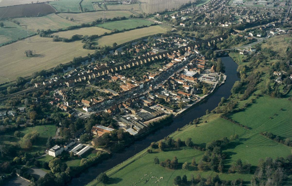


OF course there is a secret tunnel underneath Yarm. And not just one. Indeed, Yarm is so riddled and criss-crossed with concealed underground passageways that it is a wonder that the whole town – in truth, the entirety of Teesside – doesn’t collapse and disappear into one great big hole…
It all began with an innocent question in Memories 460. “My wife’s gran worked in a large house in Yarm (which one not known) and she told of a tunnel under the river,” said Paul Carter. “Do you have any ideas?”
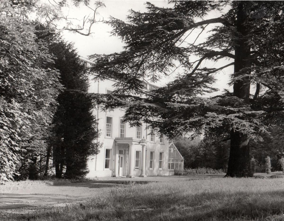
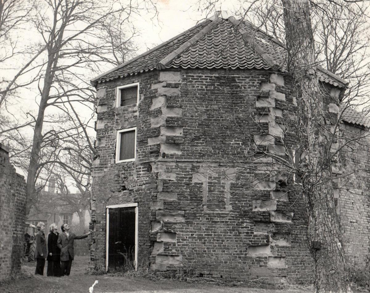
The large house would appear to be The Friarage, which is now at the centre of Yarm School.
The Friarage was built in 1770 for the Meynell family on top of the cellars of a Dominican friary which had been founded in about 1266 and which lasted until it was handed over to Henry VIII’s men in 1539.
Once it had been home to 30 friars, and it had its own, now lost, church in its grounds. A dovecote survives, once a source of food for the friars. It is said to be the oldest building in Yarm.
Lots of people have told us that the friars once had a tunnel that went down to the River Tees, apparently so that they could escape rapidly in times of trouble.
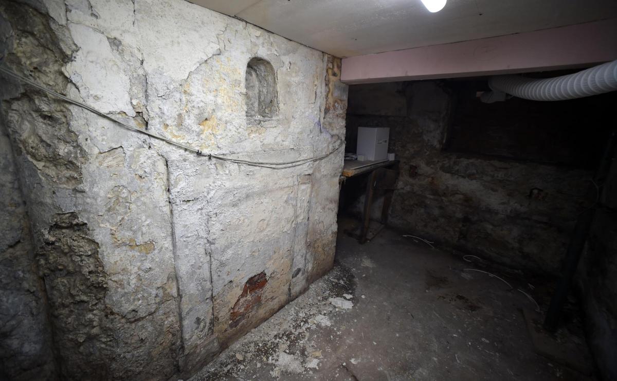
This tunnel existed until after the Second World War when it was bricked up, along with a museum’s worth of stuffed animals in glass cases that were down there as well.
It is said that if you went into this tunnel, you were not alone – not just because of the stuffed animals in the glass cases, but because of the ghosts. Friars in monkish habits haunted the tunnel – indeed, a ghostly friar was spotted as recently as the late 1970s in the grounds, along with the ghost of a nun.
It could be this tunnel, or another, that went from The Friarage, under the Tees, and up the cliff into the cellars of Egglescliffe’s ancient church. Again, there are many reports of this existence of this tunnel. Deryck Dowson, for one, remembers in his youth a friend of his investigating the tunnel from the church cellars, and he was “gone for ages”.
Then we are grateful to Christine Franklin who alerted us to an old report of a tunnel that started at The Frogery – a pond, now filled in, in the Levendale area of Yarm – which dropped down The Spital to The Friarage. Never mind the watery difficulties of starting a tunnel beneath a pond, there is a claim that this tunnel originated at Mount Grace Priory, which must be 10 miles away.
From The Friarage, The Frogery tunnel hopped over the High Street to Bentley House, a splendid early 18th Century property in the shadow of the railway viaduct.
From Bentley House, it ran beneath the High Street to Bridge House, another elderly property, in the shadow of Yarm bridge.
To this day, you can, apparently, see the entrance to the tunnel in Bridge House’s cellar.
But it didn’t stop there. The tunnel burrowed under the Tees and then headed three or more miles north beneath the A135 until it reached Stockton castle at the south end of Stockton High Street.
Stockton castle was the fortified manor house of the bishops of Durham. It was begun by Bishop Hugh de Puiset about 1170, and was stayed in on three occasions by King John between 1200 and 1212. In 1316, it was rebuilt with a moat around it, and in 1376, it was referred to as a “castle”. It was captured by the Scottish in 1644 who left it two years later in such a derelict state that it fell down soon after – the townspeople probably having a hand in its destruction as they carted off its stone to use in their own homes
They were lucky they didn’t fall into one of the many tunnels radiating out from Stockton castle.
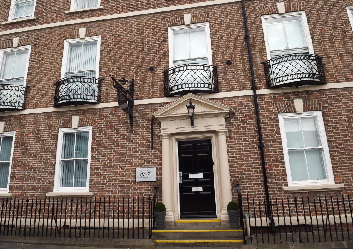
At least one, of course, ran down to the Tees. Another ran north up the High Street to the parish church, and then turned right into Paradise Row, a Georgian terrace of prosperous merchants’ homes built in the days when Stockton was a thriving seaport on top of the cellars of some older properties.
We know this because in 2016, during a £1m refurbishment of Gloucester House in the row, these remarkable cellars were rediscovered, complete with a tunnel leading off somewhere in the direction of the castle.
This discovery brought claims that as recently as the 1960s people were able to walk underground from pub cellar to pub cellar along the length of Stockton’s extremely long High Street in an extremely long tunnel.
So there must be a network of subterranean passages down there.
Some say they were dug to enable monks to escape from religious persecution. Perhaps that’s why so many of them appear to go to the river where the religious men had a habit of keeping speedboat with its engine constantly running.
Or perhaps the tunnels enabled riverborne smugglers, in the days when even tea was heavily taxed, to evade the revenue men and supply the poshest houses in the area without being seen above ground.
Or…
In the 1960s, when the Swallow hotel and the Castle Gate shopping centre were being built on the site of Stockton castle, archaeologists discovered two large brick drains dating from the 12th Century which the bishop used to flush his doings into the Tees.
Could they be the source of our tunnel stories?
Perhaps we shall find out when Stockton High Street is redeveloped in the near future.
Many thanks to everyone who has been in touch about this. We’d love to hear any further stories of any tunnels. Please email chris.lloyd@nne.co.uk
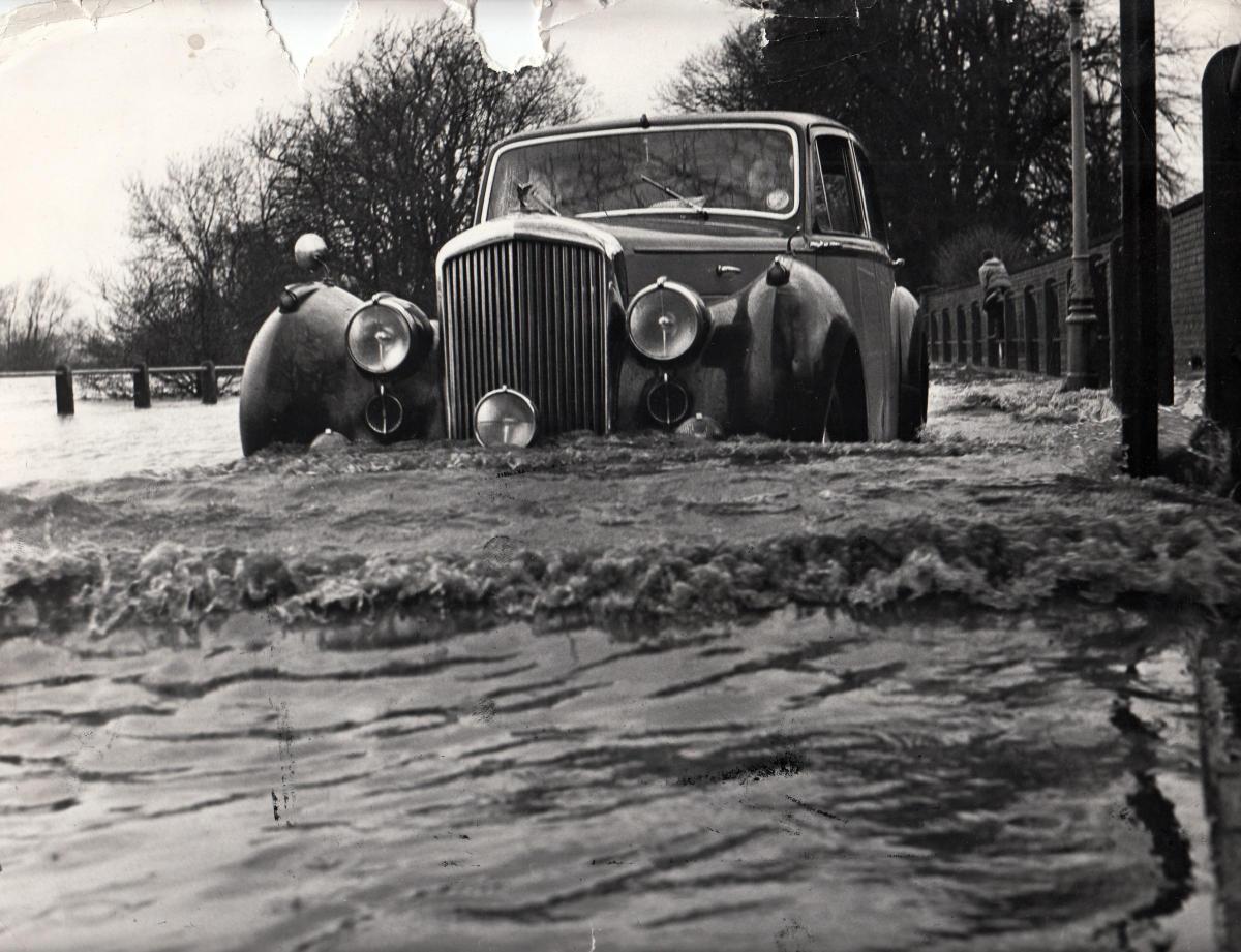
THE car pushing through the floods on the A167 at Hurworth Place on March 24, 1963 (Memories 460) was a Bentley Mark VI saloon.
That is the common consensus of our old car spotters, including Robert Pratt, Mark Cooper and John Waddleton, who was growing up with his parents in the village when the Tees and the Skerne overtopped.
Mike Crawley said: “The Bentley Mark VI saloon was produced from 1947 to 1955. It was promoted as appealing to the owner-driver-sportsman.
“It was the first car totally built throughout by Bentley as previously they’d they just built the chassis and the purchaser had got their own body made.
“The engine was rated as 4 .25 litres, 6 cylinders, 29.4 hp.
“In 1951 it was priced at £2,595 plus £721.11.8 purchase tax, so the total was £3,316.11.8 – quite a price then.”
This did not deter the driver from taking his expensive vehicle through the waters, although the car was at least eight years old by the time of the flood.
MIKE SEGGER went one better than identifying the car in the floodwater; he identified the lad on the front cover with a canoe beside the Hurworth Place phone box in the flood of March 24, 1963. It was Roy Peacock of Hurcroft House which was higher up on dry land.
IN that floody edition of Memories, we reported that in 1881, there was the greatest flood since Noah were a lad, and “5ft of water collected on land attached to the Nag’s Head – a height never before remembered”, according to the Darlington & Stockton Times.
There is still a Nag’s Head Farm on the A167 – the Great North Road – between Darlington and Hurworth Place, and it must once have been a farmhouse that doubled as an inn.
Indeed, this very week 150 years ago, the Darlington & Stockton Times reported how a “considerable number of persons” had gathered at the Nag’s Head on the Croft road for a “walking match” for a £5-1-side walking match between J Hind and J Wood, both of Darlington.
“Great excitement was evinced on the part of observers at the commencement of the walking,” said the paper, “but the match was won easily by J Hind, who completed the five miles in 48 minutes, being four minutes less than was occupied by his opponent.”
In the 16th Century, all the land between the river and the road from Blackwell to Croft bridge was known by the unattractive name of Stick Bitch or Stickabitch.
In 1740, two charitable funds left by worthies of Blackwell were used to buy an orchard called Stick Bitch which was described as being opposite the Nag’s Head. A century later, Stick Bitch was being rented out for £12-a-year which was distributed among the poor of Blackwell once a year.


Comments: Our rules
We want our comments to be a lively and valuable part of our community - a place where readers can debate and engage with the most important local issues. The ability to comment on our stories is a privilege, not a right, however, and that privilege may be withdrawn if it is abused or misused.
Please report any comments that break our rules.
Read the rules here