
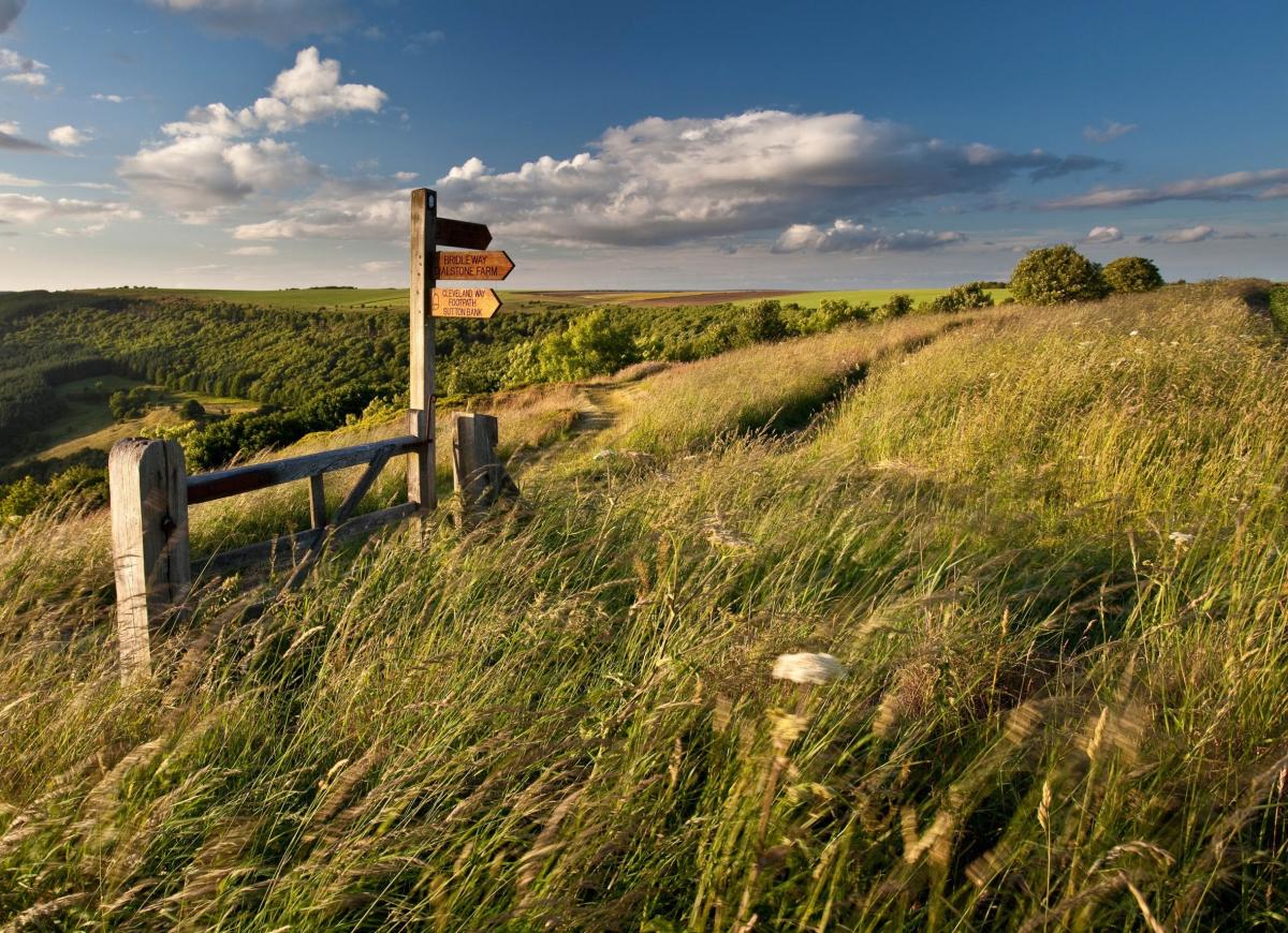
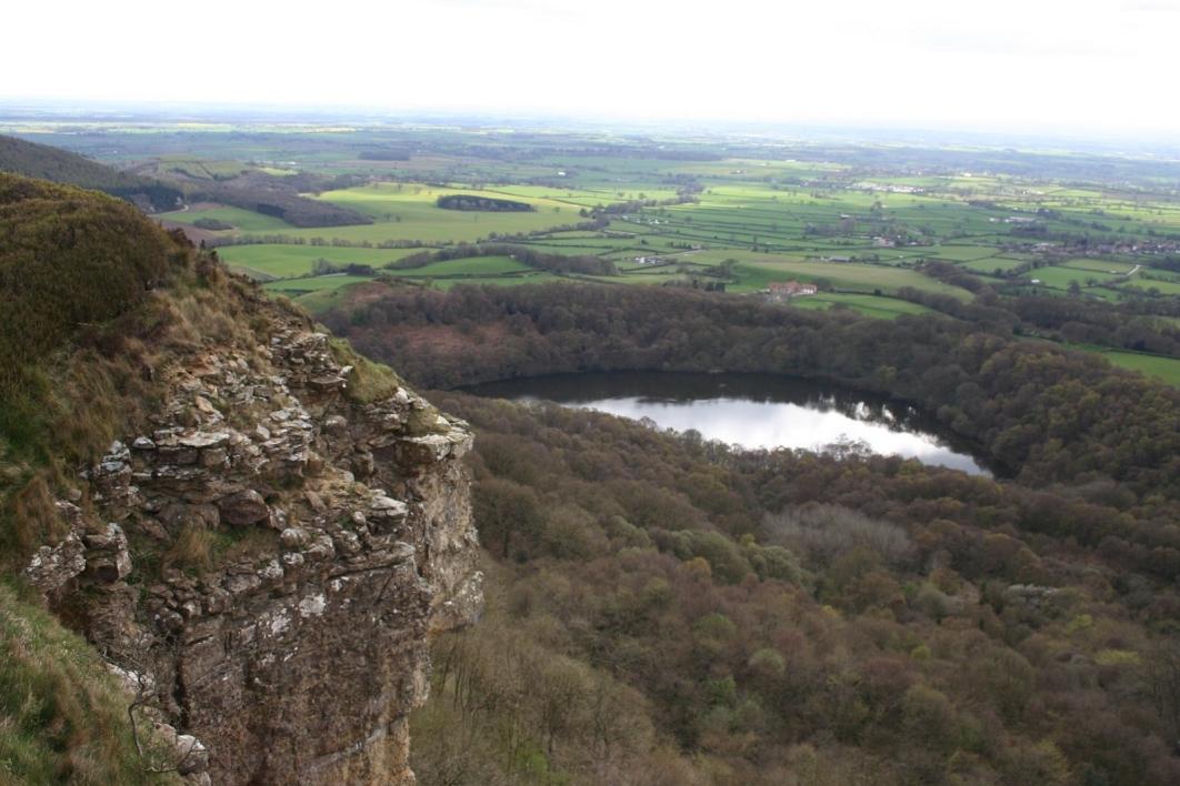
SUTTON Bank Top stands on cliffs above Sutton under Whitestonecliffe on the A170 Thirsk to Scarborough road. The area is well-known for its extensive views, particularly those reaching into the Yorkshire Dales, County Durham and south towards York. With the North York Moors National Park centre on site along with its shop, café, walks and information desk plus ample car parking, the place is often busy.
But this is no new thing. Down the centuries, this lofty and sometimes weatherbeaten point has been the focus of the meeting of the ways. Many ancient routes have merged here with others leading to welcoming dales and villages in the sheltered valleys. From here, the main roads lead to the south via York and the east via Pickering.
Sutton Bank Top, sometimes called Hambleton, was part of the route between Scotland and London centuries before the modern Great North Road was created (now the A1 or, in parts, the AlM) but the exact age of this lofty route is unknown. Some believe it is prehistoric, travellers then using the high ground for safety and practical reasons – there were dangerous swamps and the risk of attack in the lower, wooded areas.
Evidence of Bronze Age man has been discovered near the route and an Iron Age fort was found near Boltby, Thirsk. Various earthworks and dykes have also been located and it is fairly certain the route was used by the Romans, although they did not pave it as with their famous route across the North York Moors at Wheeldale, near Goathland. In that case, people in later times could not understand how this stretch of well-constructed road came to be crossing the moors and thought it must have been the work of giants, hence the folklore tale of the Giants’ Causeway.
It is highly probable that the Saxons and Normans used the Sutton Bank route over the hills and it is said William the Conqueror used it in 1069 after completing his Harrying of the North. There survives one tale of William and his army attempting to cross those heights in a severe blizzard. It was claimed his loud bad language, cursing and bullying of troops could be heard in the valleys below and that it led to an old Bilsdale saying that someone can “curse like Billy Norman”.
There is also a tale that the body of St Cuthbert of Durham was transported around the North of England to prevent it falling into the hands of the invading Danes. It was carried over this hill-top route to Crayke, near Easingwold, where it rested safely between 875 and 894. For many years afterwards, the village of Crayke belonged to County Durham, being restored to the North Riding by an Act of Parliament in 1844.
Crayke retains many links with Durham including the church, and its inn is still named the Durham Ox, but I believe that was in honour of a giant prizewinning bull.
King Edward II is said to have fled along this route in 1322 after his army was defeated at the Battle of Scots Corner, near Kilburn, and in the Middle Ages there is no doubt the road was constantly used by foot passengers and horsemen who traded with local monasteries and abbeys.
In 1633 the road from York to Coxwold became a turnpike road as far as Oldstead, but beyond that point the ancient road across the Hambleton Hills did not change. It remained an unmade track. However, the appearance of the turnpikes, a means of raising funds to maintain the roads, resulted in some travellers avoiding the tolls. Among them were drovers who moved long lines of cattle from Scotland to parts of England. An ancient unmade cross-country track such as the Hambleton Road was ideal, and so it became a noted drovers’ road.
It offered a direct route without tolls and there were plenty of good inns at the roadside, some of which still exist, albeit not all as pubs. It was a wide road with ample verges which helped in the welfare of the cattle but also the drovers. In fact, other livestock was driven along this route including pigs, sheep, turkeys and geese. Some of the lines of cattle were more than two miles long, comprising thousands of animals with several drovers and their dogs in attendance.
In the 18th and 19th centuries, therefore, this ancient route over Hambleton found itself with a busy new life. The drovers were welcomed by those living along the route. They brought both money and news to remote areas. Some of the animals required shoes, all needed rest and refreshment (animals and drovers alike) and to accommodate them were four drovers’ inns along the 15-mile route from Swainby to Hambleton. Only one of those inns – the Hambleton, near Sutton Bank Top – still functions as an inn. The Chequers Inn and Dialstone Inn are now farms, but Limekiln Inn, which served lime workers and drovers, is a ruin.
A couple of nice tales are associated with Sutton Bank Top and its links with the drovers. In one of them, a drover with his long line of cattle was passing through Hambleton close to the Bank Top while the poet, William Wordsworth, and his sister, Dorothy, were enjoying a walk. The date was July 1802 and Dorothy later wrote about the little Scotch cattle which panted and tossed fretfully about.
Dorothy and William were on their way to Brompton, near Scarborough, where William was going to marry his bride, Mary Hutchinson, in October that year. Mary had previously lived near Penrith and was a former schoolmate of Wordsworth, her family later moving to Brompton.
John Wesley came this way in 1755 and the area is still remembered for the Black Hambleton Races staged between 1715 and 1770. The Yorkshire Gliding Club’s airfield is also nearby.
Who was Rogan?
An unusual inquiry has come my way. It concerns Rogan’s Seat, which is a Yorkshire mountain some 2,200ft high and overlooking Swaledale. It is part of that massive concentration of imposing hills around Arkengarthdale and stands almost directly north of Muker on the Reeth to Kirkby Stephen road.
Both elements of the name are questioned. First, who was Rogan, and second, why is this mountain referred to as his seat? Rogan is a surname that crops up from time to time, and occasionally used as a forename. My researches have failed to find a noted person of that name who was renowned in upper Swaledale in centuries past, unless, of course, it is named after the man who discovered it.
Seat in this context can mean a site or location, and is sometimes used in connection with large houses on country estates. I don’t think the summit of Rogan’s Seat was ever a place for someone to live, or even to sit and enjoy the view. Unless someone knows differently!


Comments: Our rules
We want our comments to be a lively and valuable part of our community - a place where readers can debate and engage with the most important local issues. The ability to comment on our stories is a privilege, not a right, however, and that privilege may be withdrawn if it is abused or misused.
Please report any comments that break our rules.
Read the rules here