

USHAW Moor is a former mining village on the north side of the River Deerness, half way between Durham and Esh Winning.
Centrally located among the mining communities of the Deerness and Browney valleys, the roads from neighbouring places converge upon a crossroads at the village centre.
The crossroads was there long before Ushaw Moor came into being, although there was no housing in the 1850s when the nearest structures were Cockhouse Farm, half a mile to the west and Broom Hall on a hill to the east.
Ushaw Moor’s mining community was born in the second half of the 19th century on previously empty moorland.
Some settlement had come in the early 19th century when Ushaw College opened, but this famous institution existed half a century before the village of Ushaw Moor came into being.
There had, however, been an earlier farming settlement called Ushaw, first mentioned in 1312.
Now gone, it may have been located where College Farm stands.
Early spellings suggest that the Anglo-Saxons called Ushaw “Ulfs Shaw” meaning the Wolf’s Wood but it may well be named after Ulf, a man who held land west of Durham in the 12th century.
Little is known of early Ushaw, except that a bakehouse belonging to the Batmanson family existed here in the 17th and 18th centuries, perhaps where the college now stands. It was a communal establishment used by the poor and needy for a small fee.
Ushaw’s moorland, originally called Middlewood Moor, lay mostly east of the early settlement.
For centuries smallscale drift mining was undertaken at nearby places such as Esh, but in 1755 attempts to reach coal on the moor ended in failure.
In 1858, the Pease family opened a railway through the Deerness Valley to serve the colliery at Waterhouses near Esh Winning which stimulated the development of more mines.
After the successful finding of coal, Ushaw Moor Colliery opened about 1870. Its first owners were probably the Holliday family who owned drift mines near the village of old Esh and at the hamlet of Hill Top. By 1873 the colliery belonged to John Sharp, but passed to the aristocratic Henry Chaytor of Witton Castle in 1879.
Ushaw Moor’s first colliery village developed on the north side of Cockhouse Lane (the B6302), three quarters of a mile to the west of the present village. The early colliery village included West Terrace, East Terrace and Double Row while the colliery itself lay on the opposite side of the road, overlooking the River Deerness. The colliery and terraces were demolished in the 1950s and 1960s and are now fields.
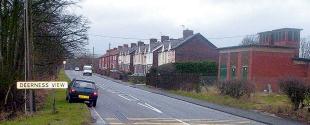
Deerness View, a lonely hamlet on the B6302, stands near to the site but does not occupy the village’s location.
Deerness View was not built until the mid-20th century, but the terraces of the earlier colliery village lay in the fields to its east.
There had been development of buildings around the crossroads in what is now the centre of Ushaw Moor before the 1890s.
Buildings included a pub called the Flass Inn, but the population was concentrated in the terraces of the earlier village further to the west.
Cockhouse Lane leads to Esh Winning and Waterhouses, but before those collieries developed the lane terminated at Flass Hall, a mile east of Ushaw Moor. The hall’s name derives from an Old Danish word, Flask, meaning swamp and has the same meaning as Flass Vale in Durham.
Established in the 1570s, the hall is in reality a farmhouse and lies on the site of a mediaeval farm that is marked on Saxton’s map of Durham in 1576. The hall’s first occupant was William Brass who was succeeded by his son, Cuthbert in 1600. The last Brass at Flass still lived there in 1697 when it became the home of the Hall family.
By the 19th century, Flass belonged to Jane Smythe, of Esh Hall, who married Sir Robert Peat, a friend of the Prince Regent. Robert had serious gambling debts and had probably married Jane for her money.
Later, they were estranged, partly because of Jane’s kleptomaniac tendencies. She chose to live in Sunderland, renting Flass Hall to the Rev Temple Chevalier of Esh village while her property at Cockhouse Farm was leased to John Leadbiter of Gateshead.
Flass Hall became a property of the Peases in the 1920s before passing in the 1930s to a local farmer who kept pigs in the house. It was taken over by the National Coal Board in 1947 and converted into private houses in the late 1960s.
Locally it is called “haunted house”, but the identity of its spectral resident, if indeed there is one, remains a mystery.
Broom Hall is another notable hall. Once situated in empty fields east of the village until almost swallowed by Ushaw Moor’s housing developments in the 1960s, it belonged to the Batmanson family in the later half of the 16th century.
However, Broom Hall is really associated with the little village of Broom to the east.
Broom is now called Broompark but Broompark was really the name for the adjoining colliery village that developed in the 19th century.
The colliery village has gone and is now occupied by a housing development called Cooke’s Wood, but older parts of Broom including several old farmhouses remain.
Broompark is only separated from Ushaw Moor by a road and recreation ground. Mining had taken place on a small scale here since the 1300s when its coal was sold to the Prior of Bearpark.
The North Brancepeth Colliery Company, which also operated Littleburn colliery, opened the colliery at Broompark about 1870 on the site of a mysterious mediaeval moat. There are no traces of the moat and the colliery closed in 1904 after a major fire from which the miners escaped by means of an old drift.
One intriguing feature of Broompark is the Loves public house. Built in the 19th century it was originally called Love’s Hotel after Joseph Love, a Durham coal owner who owned a brick foundry. He is thought to have built the pub with his bricks, each of which was inscribed with the word “Love”.


Comments: Our rules
We want our comments to be a lively and valuable part of our community - a place where readers can debate and engage with the most important local issues. The ability to comment on our stories is a privilege, not a right, however, and that privilege may be withdrawn if it is abused or misused.
Please report any comments that break our rules.
Read the rules hereComments are closed on this article