
Businesses bloomed where buses now pull in
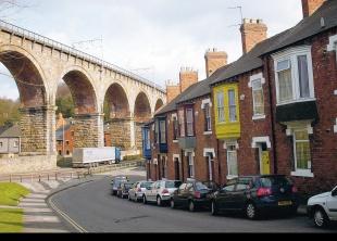
DURHAM’S North Road dates from 1831 and has been compared to the shopping street of a typical mining village, but while there was never a colliery in this part of the city, the area around North Road was once a hive of industrial activity.
Durham City bus station, on the eastern side of the road, is undoubtedly the busiest spot in the street today.
Originally topped with an ornate iron and glass structure of 1928, it was sadly removed in 1976 and taken to Beamish Museum for storage.
Few travellers visiting Durham station today know that it was once the site of a large corn mill called the North Road Steam Mill or City Mill.
From the 1840s, it belonged to a man called John Robson who also owned the Market Place Mill, of which remnants can be seen near the site of the former ice rink.
North Road mill was powered by means of a stream, called the Mill Burn that now flows in a culvert beneath the city’s streets but its course can still be traced in Flass Vale from where it flows underground, roughly following the course of Waddington Street.
It then passes beneath the terraces behind North Road and then underneath North Road itself before entering the river by pipe at Framwellgate Waterside opposite the site of the Market Place Mill.
In the 1860s, the North Road corn mill business was taken over by a Mr Hill, but by 1873 he was operating the Market Place Mill when the North Road establishment seems to have fallen back into the hands of the Robsons.
Mr Hill is listed as miller at both establishments by the end of the 1870s, and like his Robson predecessors resided at Neville House, the grounds of which now form part of the bus station.
This big house dates from 1842 and can still be seen.
Hidden behind North Road, it has a distinctly Georgian appearance and overlooks the bus station.
Tightly-packed terrace houses occupy the area around the bus station between North Road and neighbouring Allergate.
These are early 20th century terraces built of red brick and are named New Street, Mitchell Street and East Atherton Street.
The name of New Street is not what it seems. It is named after the Eaglescliffeborn William New, who lived nearby in Flass Street.
Mr New was a prominent member of Durham’s Co-operative movement, an organisation that built some of the terraces hereabouts.
East Atherton Street is an offshoot of the original Atherton Street that dates back to the 19th century.
This was named after Sir William Atherton (1806-64), a one-time resident of the city who became MP for Durham in 1852. In 1859, he would become the Solicitor General for the nation and was noted as a proponent of electoral reform.
Atherton Street dates from the 1860s but parts of the street adjoining North Road were demolished in 1970.
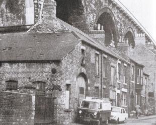
In times gone by, Atherton Street was principally famed as the home of Hauxwell’s Iron Foundry and Engineering Works. It was one of the best-known firms in the city.
Situated at 8 Atherton Street, the firm was established by George Hauxwell, who was born at Great Ayton in North Yorkshire in about 1826. He moved north from Yarm, near Stockton, and established his works in Durham, near the viaduct, in around 1860.
In the 1870s, the firm acquired a rival foundry belonging to the Coulsons in the neighbouring street of Crossgate.
In his later years, Hauxwell’s three sons, William, Robert and George junior, assisted George in the business and the firm came to be known as George Hauxwell and Sons.
By the time of the 1881 census, when George described himself as an iron founder and engine maker, the firm employed 22 men and eight boys. Most of the foundry workers seem to have lived in the Crossgate area of the city.
Over the years, Hauxwells was involved in all kinds of industrial activities, as colliery engineers, millwrights, iron founders, farriers, heating engineers and welders.
One particular legacy of the firm was its manhole covers that can still be seen across Durham today.
George Hauxwell became a JP and alderman in Durham and died in 1897, but his firm continued to operate during the 20th century.
The building that housed the old foundry was unfortunately a part of Atherton Street that underwent demolition about 1970.
The demolitions, which also affected some houses in neighbouring Sutton Street were necessary to make way for the new roads connected to the Castle Chare and North Road roundabout.
A new section of Sutton Street that forms part of the A690 runs parallel to the viaduct and cuts through the old iron foundry site near the roundabout.
On the immediate north side of the viaduct, part of the earlier Sutton Street survives along with an attractive 19th century terrace, called Lambton Street near the corner of which stands a Chinese takeaway.
This was one of the many terraces built in Durham in the years following the opening of the viaduct in 1857 but is not built with the usual red bricks that typify the terraces of the area. It is a surprisingly attractive street.
Nearby, and close to the takeaway, is a creamycoloured stone building called Bees Cottage that predates the surrounding terraces.
It was perhaps associated with the family of a diarist called Jacob Bee who lived in Durham until his death until 1711, but I cannot be certain of this. In 1881, it was home to a woolspinner called Amos Tromer, but from the 1920s it was home to Luke’s Bakery who owned bakery shops and a café in Durham City.
In recent times, the cottage served as a guesthouse, but is now privately owned.


Comments: Our rules
We want our comments to be a lively and valuable part of our community - a place where readers can debate and engage with the most important local issues. The ability to comment on our stories is a privilege, not a right, however, and that privilege may be withdrawn if it is abused or misused.
Please report any comments that break our rules.
Read the rules hereComments are closed on this article